


Hurricane Matthew is strengthening again.
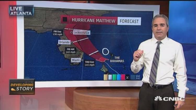
After barreling through Haiti, Cuba and the Bahamas, the storm is expected to hit the east coast of Florida on Thursday night.
The storm had earlier shown signs of weakening — particularly when it was moving over the mountainous terrain of Haiti and Cuba, but since then it has intensified.
There are a number of factors that can drive the intensity of a storm, but a few notable ones meteorologists look for. Most importantly, hurricanes form over warm ocean waters near the equator.
The air in these areas is warm and moist — the high temperatures cause water to evaporate off the ocean's surface. As the air rises, cooler air rushes in from above to fill its place near the surface of the water. Then this air heats up and rises as well. As the air rises, it cools and clouds form. The eye of a hurricane is actually an area of low pressure where the cool air is sinking toward the surface of the ocean.
There are variables that can slow down or break up hurricanes, including land, cold water and wind shear — winds traveling vertically disrupt the horizontal winds that make storms.
But the conditions in the Caribbean have so far helped Matthew intensify. Sea surface temperatures in the Caribbean are nearly bathtub warm at around 85 degrees, according to NOAA's SHIPS model. There is low wind shear (around 9 knots) and plenty of atmospheric humidity.
The storm's Saffir-Simpson rating was bumped up to Category 4 on Thursday morning.
Saffir-Simpson rates the speed of hurricane winds, and is meant to give an idea of what kind of damage a storm can wreak. The scale rates storms from 1 to 5, with the top three categories being considered "major" hurricanes.
A Category 1 storm has sustained winds of 74-95 mph, while a Category 5 storm has winds of 157 mph or higher. A Category 4 storm such as Matthew has winds of 130-156 mph. Both Category 4 and 5 storms create "catastrophic damage," according to the National Hurricane Center. This can include severe damage, or even the total loss of homes, uprooted trees and power outages that last weeks or months, rendering some areas uninhabitable.
In Matthew's case, after 24 hours, the storm is likely to weaken as it hits land, according to a Thursday morning forecast from the National Hurricane Center. Increasing wind shear should also cause winds to lose speed, it said.
Correction: A Category 1 storm has sustained winds of 74-95 mph. An earlier version misstated the range.