


Back in November, the United Nations World Meteorological Association said that the 2015-2016 El Nino was on track to be one of the strongest ever, and that severe weather posed dangers to millions of people.
It's beginning to look like it was right.
The United Nations' under-secretary-general for the coordination of humanitarian affairs, Stephen O'Brien, said Thursday that El Nino has pushed the planet into "uncharted territory."
"The impacts, especially on food security, may last as long as two years," he said in a U.N. news release. Regions especially affected include Central and South America, the Pacific region and East and southern Africa.
That said, warm ocean temperatures in the Pacific — a key indicator of an El Nino — are already beginning to cool, and may have peaked. The Australian Bureau of Meteorology issued a statement earlier this week saying exactly that.
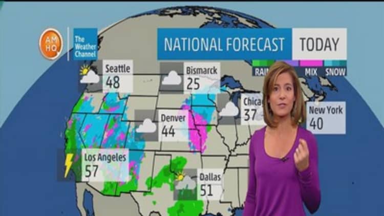
When we look back at all of our winters, February is always the wettest month, and that is especially true when we have El Nino conditions like this.Mark Jacksonmeteorologist, National Weather Service
However, it is too soon to known what sort of effect ocean cooling will have on weather patterns.
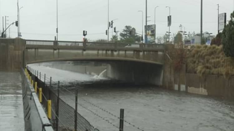
Heavy rains have only recently begun to fall in Southern California, later than meteorologists expected. Three big storms hit the Los Angeles area this week, and another is expected to arrive Saturday.
Those weather systems have delivered much relief to the drought-stricken region — even bringing the dry Los Angeles River roaring to life — but they have also caused flooding, strong winds and high surf along the coast.
The Federal Emergency Management Agency in December released a Severe El Nino Disaster Response Plan for California, Nevada and Arizona.
Though California has been in the middle of a drought, Mark Jackson, meteorologist in charge at the National Weather Service-Los Angeles, told CNBC he was still a bit surprised by the delays in rainfall.
"November and December were extremely dry [in Los Angeles], drier than they were last year," Jackson said. "That is not what typically happens with an El Nino season like this."
"I would have thought that a week like this would have come three weeks ago," he added. "But no two El Ninos are alike."
Other patterns have left scientists scratching their heads, such as heavy snowstorms in the Pacific Northwest, which are also atypical for an El Nino year.
"There is not necessarily a one-to-one correlation" between ocean temperatures and weather patterns, Jackson said. "Just because the temperatures are cooling does not mean the storms are going away."
The National Weather Service's Climate Prediction Center will be issuing a new three-month outlook next Thursday, but Jackson said he expects the wet weather in the southern regions of the country to continue through March.
"We can get these storms any time of year, but back in October and November, when we saw there were strong El Nino conditions existing, we know from looking back though the years that when we get (El Nino) events like this, rain will pick up usually in January, February and March," he said. "So this is one sign that we may be in store for a wet first quarter of the year."
Jackson added, "When we look back at all of our winters, February is always the wettest month, and that is especially true when we have El Nino conditions like this."