Wednesday's weather models reinforce that Hurricane Gustav could be the most powerful storm to rip through Gulf of Mexico oil and gas production areas since Katrina. It will be the first storm to test the industry's efforts to reinforce its oil and gas production infrastructure.
U.S. light, sweet crude oil , natural gas and gasoline are all moving higher, in part on worries about the storm.
The National Hurricane Center says it could be a category 4 and some models show it aimed straight for Louisiana or Mississippi by Monday morning. Models also show it landing anywhere from Pensacola, Fla. to Corpus Christi, Texas; one even shows it going to Mexico, before heading back into the Gulf.
The storm, which quickly developed into a hurricane Tuesday, fizzled to a tropical storm as it moved over Haiti, but it is expected to regain strength as it moves across the water.
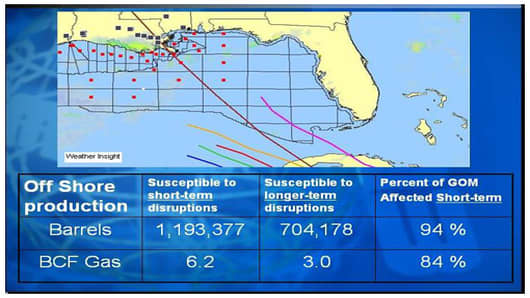
Weather forecasters warn that Gustav's path is far from determined, but Aaron Studwell of Weather Insight says there's a 70 to 75 percent chance the storm will hit the central Gulf Coast.
He says he believes that it will not necessarily head for New Orleans as some models suggest, but could land a bit away from the city -- closer to Lake Charles and the Henry Hub, the main collection point for gas pipelines as they go on shore.