


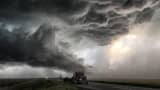
Spring was expected to move across the central U.S. like a lion Wednesday with more than 18 million people potentially facing severe weather.
Blizzard conditions, high winds, flash flooding, large hail and tornadoes were among the hazards, NBC News meteorologist Bill Karins warned.
The area at greatest risk of tornadoes stretched from northeast Texas into northern Louisiana and western Mississippi, according to Karins. Isolated tornadoes were also possible from Arkansas to Iowa.
Read more from NBC News:
Rubio makes bid to keep delegates
Prince William rescues oblivious patient
Flint official: State overruled water treatment plan
Karin said that heavy rain expected over the next two days could see the return of flooding to Louisiana, Alabama and Mississippi.
"Northern Texas — including Dallas — have the highest chance to see tornadoes today," Weather Channel senior meteorologist Juan De Cardenas said. "This is normally the time of the year on the Plains for severe weather. This is pretty much on time."
This severe weather was forming as warm moist air moved inland from the Gulf of Mexico and met cool air from the West. As the two fronts meet, it creates a "shear" between the layers of air in the atmosphere.
"The low-level jet transfers warm moisture from the Gulf and high-level jet brings cold air from the West and Southwest to create a shear in the atmosphere," De Cardenas added. "This helps create a spin which forms tornadoes."
